Micro-mapping Apartheid: Archives, Stories and AR
David A. Wallace, Siddique Motala
We are two academics who met in Cape Town when our children became friends. Conversations around our shared interests in history, technology and Cape Town’s District Six got us speculating about social justice pedagogies in our respective disciplines. Our preliminary discussions revealed many parallels in our approaches but also intriguing distinctions, enough to seed a commitment to collaborate. At the time, Siddique was teaching geomatics students who were studying towards qualifications in land surveying and Geographic Information Systems (GIS) at the Cape Peninsula University of Technology (CPUT). David, an archivist, was organising immersive professional experiences for University of Michigan (U-M) graduate students with NGOs in Cape Town through his school’s Global Information Engagement Program (GIEP). In this article we discuss our three-plus years of collaboration to enhance social memory through joining traditional primary sources with emerging information technology tools in District Six, with emphasis on our latest effort to integrate Augmented Reality (AR) with GIS, archives, and storytelling.
District Six in Cape Town is perhaps the most well-known site of apartheid forced removals (some 60,000 Black individuals between 1968 and 1983). It was a cosmopolitan, multi-racial and multi-denominational urban community viewed by the government as a slum that violated the edicts of apartheid’s ‘separate development’ segregation ideology. It was also favourably located close to the city centre, nestled in between Table Mountain and the sea. Upon removal of the residents, almost every building (houses, community halls, shops, public amenities, health facilities, cinemas, nightclubs, hotels, factories, businesses) was demolished by bulldozers, except for a few mosques, churches and schools. Today, the site sits largely unreconstructed and its legacy and future remains deeply contested. The last four months of 2021 saw District Six mired in controversies over redevelopment planning, city evictions of the homeless, restitution and resettlement for ex-residents, and increasingly realised fears that many returning claimants will pass away before securing one of the District’s newly constructed homes (Bantom, 2021; Charles, 2021; Lepule, 2021; Thebus, 2021).
Our collaboration started in 2018 and builds on the surveying and mapping work carried out by Siddique on the site since 2006. As a much-needed decolonising pedagogy in engineering education, Siddique attempted to conscientise students to the socio-political-historical aspects of the site that their university was situated on. The university, which was originally called Cape Technikon, was built on a large portion of the demolished District Six, and was a Whites-only institution during apartheid. In Cape Technikon’s curriculum, District Six’s troubled history was silenced and buried under the technical language of geomatics. Fieldwork tasks were ahistorical – the rubble under their feet was nothing more than land that needed to be accurately measured and represented on a map. This needed to be changed, and Siddique’s students started to dig up the past, linking mapped locations to what (and who) used to exist there before.

Figure 1: District Six aerial photographs. Top left – 1953; Top right – 1968; Bottom left – 1983; Bottom right – 2019.
Figure 1 shows four GIS maps of the same geographical space. The red line is the outline of District Six, the area that was declared Whites-only in 1968. One can observe the drastic changes on the landscape. In 1953, District Six was fully developed, with narrow streets and dense concentration of buildings. By 1968, the first signs of demolition were observable. In 1983, District Six resembled a war zone, with most buildings destroyed, and in 2019, much of the district was open space, with the CPUT campus a dominant feature.
Our first efforts in 2018 were consciously designed as an interdisciplinary effort to join geomatics, archiving, and storytelling. We sought to virtually reconstruct aspects of District Six in terms of the lost built environment and stories of still living ex-residents and their experiences before, during, and after demolition. We brought together a wide range of stakeholders, including ex-residents, St. Mark’s Church (one of the few structures that survived demolition), the District Six Museum, GIEP, and the departments of Town & Regional Planning and Civil Engineering & Surveying at CPUT. St. Mark’s then current rector wanted to foreground the church’s history and reached out to Siddique. At an early project planning meeting at St. Mark’s, we pitched the idea of using its baptismal records and integrating them with Siddique’s mapping efforts and the memories and archives of selected ex-resident parishioners.The baptismal records date from the late 1800s and are a potent symbol and source of District Six’s heritage, documenting individuals, families, social networks, livelihoods and how they manifested across space and time.
We created a prototype demonstrating that it’s possible to accurately plot the addresses extracted from the baptism records and connect them to the life stories of ex-residents. The prototype selected and mapped approximately 2,000 baptisms between 1950-1958. This was a detailed undertaking that involved onerous human and computing efforts of extracting, checking, and scripting to clean the data. CPUT students created a GIS map that geolocated addresses and integrated it with maps of other sites in District Six. This work represents the first comprehensive digital historical spatial record of District Six that contains discrete and granular locations of a diverse range of important sites (such as businesses, public services, streets, and the homes of baptised babies). Figure 2 shows some of the sites, overlaid on the 2019 map.
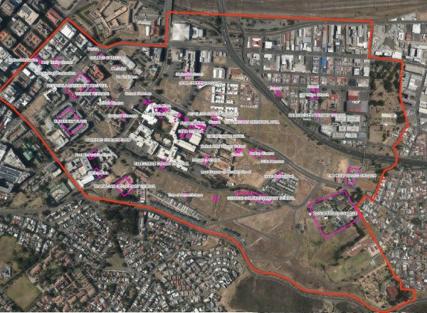
Figure 2: Geo-location of specific sites in District Six on the contemporary landscape.
A collaborative exercise with the GIEP team confronted the vagaries of deciphering handwritten baptism entries, confirming and normalising street names and addresses and locations. We worked with St. Mark’s to identify ex-residents who were willing to share their District Six experiences through recorded oral histories supplemented by their own personal archives. Six ex-resident St. Mark’s parishioners agreed to participate. Interviews covered a range of community members. Each participant was photographed with their baptismal record, and copies made of any records they chose to bring in to aid their storytelling, such as childhood photographs and/or mementos. All generated materials from this iteration – including the digitised baptism registries, the oral history methodology, permissions, and oral history recordings – was deposited with the District Six Museum under a deed of gift. (Huang, Leal and Rubin, 2018).
In 2019, we built upon this work with a second GIEP and CPUT cohort. The District Six Museum hosted this effort. In this iteration, we sought to strengthen our oral histories, identify and plot key landmarks on the GIS map, and integrate all of this as a publicly accessible interactive multimedia website. We re-interviewed five of the six 2018 storytellers and added two new ones. We mined the District Six archives to locate archival images and supplementary primary sources of twenty-nine landmarks: eight social centres, a hospital, nine places of worship, seven schools, and 4 cinemas/bioscopes. Finally, we integrated all of this information onto the museum’s website as an online experience that enables visitors to overlay historical District Six with the contemporary landscape, learn storytellers’ biographies through geolocated photographs, documents, and audio, and identify, locate, and learn about historically significant landmarks (Cox et al, 2019). This effort is now hosted by the District Six Museum’s website as the ‘St Mark’s Memory Mapping Project’ (Figure 3). Siddique’s follow-up work, a 21 minute video provides vivid evidence of the fruits of joining geomatics and archiving to tell the story of erased pasts (Motala, 2019).

Figure 3: Snapshot of the St. Mark’s Memory Mapping Project website.
Over the past two years, Siddique developed a ‘Haunted Walks of District Six’ walking tour, using analog printouts of the GIS map and historical images of the tour’s stopping points. To date, this analog version of Haunted Walks has been delivered to some 200 individuals – academics, students, artists, filmmakers, and ex-residents. The goal is to provide walkers with a deeply affective and transformative experience by integrating the primary sources described above with real time traversing of the contemporary landscape. This approach deploys the ‘counter-surveying’ methodology, which combines land surveying and mapping to find and mark the locations of sites on the physical landscape that no longer exist (Motala and Bozalek 2021). This method can identify the exact locations of demolished homes in the present day for the benefit of ex-residents, as well as to locate other sites to reinforce and graphically illustrate the gravity of what was lost during demolition.
We now believe that the current analog version of the walking tour needs to be reimagined, strengthened, and experientially enriched with the thoughtful incorporation of digitised and digital content via AR technologies. As an interactive technology that runs in real time and registers and co-locates contemporary and virtual historical objects with one another through handheld devices such as mobile phones and tablets, AR is a logical next step in our collaboration. We are now recasting the Haunted Walks tour as an AR enhanced experience. Users will be directed to the precise locations of important demolished sites in District Six and be shown what used to exist at that location through stories, superimposed archival images, documents, videos and sound clips. AR will enable walking tour participants to immerse themselves simultaneously in both the contemporary and historically erased landscape, essentially co-geolocating themselves across time.
To continue this work, in 2021 we received a collaborative faculty seed grant from U-M’s African Studies Program’s African Heritage and Humanities Initiative, running through 2022. This work is directed towards a decolonial praxis based on connecting developments related to our scholarship in social justice geomatics (Zembylas et al 2021) and archival social justice (Wallace et al 2020). It will explore new heritage-related theoretical and praxis directions for engineering, archiving, information technology (AR and GIS), and their intersections in social justice memory work. Work is proceeding along three axes, 1. Theoretical (joining counter-surveying and social justice archiving to probe the intersections of ephemerality, affect, and non-institutionalized memory making); 2. Methodological (development of counter-surveying and memory making and transmission praxis) 3. Socio-technical (incorporation of AR to transform the Haunted Walks experience). We will reinvent the embodied experience of the Haunted Walk, with prospect for application to other contexts of forced removal, recovered and contested memory, and ongoing justice-seeking and activist efforts (acknowledgment, memorialisation, restitution, and reparations).
However, we also take seriously the advice of Tuck who warns against such work as being solely aimed at the documentation of damage. Whilst damage-centred narratives are often collected and deployed benevolently, the resulting work provides a one-dimensional view of Blackness and disenfranchised communities (Tuck & Yang, 2014). We seek to meaningfully contribute both to more fine-grained understandings of apartheid planning practices and the experiences of those subjected to them. Instead of solely focusing on the documentation of damage, we are equally ‘concerned with understanding complexity, contradiction, and the self-determination of lived lives’ (Tuck, 2009, p. 416). We also want to attract a younger generation of technologically adept South Africans, which is especially critical in light of the nation’s ongoing efforts to decolonise its curricula and grapple with its apartheid past and its afterlives. Through this community-based work, we seek to leverage creative technologies, stimulate affective responses in walker-users, and assist students and researchers in reimagining the historical remnants of the ex-apartheid city and its continued effects on the contemporary urban landscape.
To date we have laboured to reimagine and reconstruct the walking tour as an AR app by plotting out specific notable and not well known points of interest. We are collaboratively working with the District Six Museum’s archives to identify photographs that can be precisely located and superimposed onto the contemporary landscape. We have ideated and envisioned the user experience via a 2.5km walking loop and how that will manifest as virtual content delivery and interactivity via historical narratives and stories and locational positioning in the real world. We have identified necessary pragmatics of pre-tour set-up (route and tour points, disclaimer and liability waiver, operationalising the tour on users’ devices, interface design, location awareness, and toggling between the historical and contemporary landscape), user orientation to and experience at tour points (navigation, multimedia content display of text, audio, visual and moving image, overlaying historical photos on the contemporary landscape), and ending (feedback, sharing on social media, contact information).
The biggest early challenge has been identifying and evaluating the tradeoffs on alternative AR platforms, given due consideration of the constraints facing prospective users in District Six: device requirements and operating system; navigation; data usage, and; feasibility to realise the completeness of our vision. We want a user to be able to use an Android smartphone or tablet to download our app and be empowered to take a self-guided tour. Project staff have explored AR possibilities mindful of these needs. We have evaluated the status and capabilities of available AR tools / applications along the following parameters: functionality; usability; learnability; incorporating multimedia content and geolocational data; content management; open source vs proprietary; costing; editability, and; prospects for persistence (longevity). After carefully reviewing nine alternative possibilities, we are using Unity3D as our AR authoring environment. It will allow us to integrate our GIS maps, develop our own user interface, activate the user device’s GPS for navigation and camera for transposing historical photographs onto the contemporary landscape.
Parallel to the AR effort, project staff are modifying the current analog version of the tour by developing a curated digital repository of existing and new archival and other supporting primary source materials. This will strengthen and expand walking tour content. This will be supplemented by the development of new and expanded tour narratives / storytelling. For example, we envision that one of the points that will be visited through the app will be Horstley Street (Figure 4), which was an important street in the history of District Six. The buildings of Horstley Street were completely razed, but the original cobblestone street remains.

Figure 4: Horstley Street before demolition (left, District Six Museum archive) and today (right).
Ultimately we value the expansion into AR not as technology for its own sake but rather as a tool to create powerful affective embodied experiences for walkers-users. It is one thing to see the remnants of District Six as pins located on digitised historical and contemporary aerial photographs, as was done with our previous work. We believe the embodied and embedded process of walking across the contemporary landscape to visually ‘see’ what used to be there provides a more tangible, meaningful, and moving experience that will create a lasting impact. We anticipate launching the app in 2022.
Bibliography
Bantom, K (2021), ‘D6 ‘caretakers’ named,’ news24, 14 September [online]. Available at: https://www.news24.com/news24/SouthAfrica/Local/Peoples-Post/d6-caretakers-named-20210913 (Accessed 13 December 2021)
Charles, M (2021), ‘City of Cape Town evicts homeless in District Six during massive operation,’ news24, 20 September [online]. Available at: https://www.news24.com/news24/southafrica/news/watch-city-of-cape-town-evicts-homeless-in-district-six-during-massive-operation-20210920 (Accessed 13 December 2021)
Cox, V, Dall, V, Qui, V and Yelk, J (2019) ‘St. Mark’s memory capture and interactive mapping.’ (Global Information Engagement Program, School of Information, University of Michigan)
Huang, J, Leal, M and Rubin, M (2018) ‘Final report: St. Mark’s community heritage and baptismal record project.’ (Global Information Engagement Program, School of Information, University of Michigan)
Lepule, T (2021) ‘Claimants dying off before ever returning to District Six,’ Weekend Argus, 28 November [online]. Available at: https://www.iol.co.za/weekend-argus/news/claimants-dying-off-before-ever-returning-to-district-six-b8f3ed06-866c-4185-82eb-a9ac13c67d0c (Accessed 13 December 2021)
Motala, S (2019) “District Six and CPUT: a carto-story.” Available at: https://www.youtube.com/watch?v=iEzydbcVWV4 (Accessed 13 December 2021)
Motala, S and Bozalek, V (2021) ‘Haunted walks of District Six: propositions for counter-surveying,’ Qualitative Inquiry [online]. Available at: https://doi.org/10.1177/10778004211042349 (Accessed 13 December 2021)
Thebus, S (2021) ‘Plan to resettle District Six claimants plods along,’ Cape Argus, 16 September [online]. Available at: https://www.iol.co.za/capeargus/news/plan-to-resettle-district-six-claimants-plods-along-113c2d18-f4b8-48f4-a6fe-eefa89235742 (Accessed 13 December 2021)
Tuck, E (2009) ‘Suspending damage: A letter to communities’. Harvard Educational Review, 79(3), 409–427. Available at: https://doi.org/10.17763/haer.79.3.n0016675661t3n15 (Accessed 14 December 2021)
Tuck, E and Yang, KW (2014). ‘R-words: refusing research’ in Paris D and Winn, MT (eds.) Humanizing Research: Decolonizing Qualitative Inquiry with Youth and Communities. Thousand Oaks, California: SAGE Publications, 223–248. Available at: https://doi.org/10.4135/9781544329611.n12 (Accessed 14 December 2021)
University of Michigan (undated) ‘Engaged learning,’ [online]. Available at https://engaged.umich.edu/engaged-learning/ (Accessed 13 December 2021)
Wallace, D, Duff, W, Saucier, R, Flinn A (eds.) (2020) Archives, recordkeeping & social justice. London: Routledge
Zembylas, M, Bozalek, V, and Motala, S (2021) A pedagogy of hauntology: decolonising the curriculum with GIS. In Bozalek, V, Zembylas, M, Motala, S, and Hölscher, D (eds) Higher education hauntologies: living with ghosts for a justice-to-come Oxon: Routledge, 11-28). DOI: 10.4324/9781003058366
Related posts
What3words as a storytelling technology in Pin the Tale
What3words is a tool that allows you to communicate your location – wherever you are on earth – using three words. It is backed by a geolocation system that has divided the world i...
What3words is a tool that allows you to communicate your location – wherever you are on earth – using three words. It is backed by a geolocation system that has divided the world i...
New Media Writing Prize 2014 Open for Entries
Submissions for the 2014 prize are open from now until the 28th November (12th December is the deadline for Student submissions). The New Media Writing Prize, now in its fourth ...
Submissions for the 2014 prize are open from now until the 28th November (12th December is the deadline for Student submissions). The New Media Writing Prize, now in its fourth ...
Provocare: A New Digital Story Exploring Female Agency and Violence Against Women
Recently launched, ‘Provocare’ is a multimedia verse thriller created by Meg Vann, writer; Mez Breeze, interaction designer; and Donna Hancox, research lead for Creative Industries...
Recently launched, ‘Provocare’ is a multimedia verse thriller created by Meg Vann, writer; Mez Breeze, interaction designer; and Donna Hancox, research lead for Creative Industries...
Theme: Activism and social change through storytelling
Since the beginning of 2021, we at The Writing Platform have been taking a deeper look at all kinds of digital storytelling and have begun to publish our articles around several th...
Since the beginning of 2021, we at The Writing Platform have been taking a deeper look at all kinds of digital storytelling and have begun to publish our articles around several th...
MIX 2025 Call for Presentations
Wednesday 2 July 2025 at Bath Spa University’s Locksbrook Campus Now in its eighth year, Bath Spa University’s MIX has established itself as an innovative forum for the disc...
Wednesday 2 July 2025 at Bath Spa University’s Locksbrook Campus Now in its eighth year, Bath Spa University’s MIX has established itself as an innovative forum for the disc...
Beyond the Book: The Beginning
Paper Nations, a South West England-based creative writing incubator dedicated to diversity and innovation, has commissioned three writers with links to the region to develop excit...
Paper Nations, a South West England-based creative writing incubator dedicated to diversity and innovation, has commissioned three writers with links to the region to develop excit...